In addition to these websites, the United States Geological Survey (USGS) is a reliable and inexpensive source for maps. USGS maps can be found at sporting goods, surveying and travel stores. The best type of USGS topographic map to use for an asset inventory is the 7.5-minute topographic map. The 7.5-minute topographic map, with a scale of 1:24,000, is the largest-scale map available and offers the most detail. Each 7.5-minute topographic map is given a quadrangle name (also referred to as a quad name). This name is required in order to find a map of your specific area. There are index maps available through the USGS to help determine which maps are needed to cover your area. The one drawback in using USGS topographic maps is that rural areas are not updated as frequently as urban areas. However, the maps can provide a useful starting point in creating an asset map because they contain useful information such as the scale bar, contour lines, and latitude and longitude coordinate. Depending on the age of your utility, the USGS may have already mapped features such as the water tank or water well, since the USGS typically documents manmade features. Digital aerial photographs (also known as orthophotographs) may be ordered from USGS or can be accessed from TerraServer-USA. These maps are easy to print from a home computer. There are also data information research companies who specialize in researching aerial photographs. These companies will charge a research fee and the cost of the photographs. The utility can save this cost by doing the research using the following web sites.
- Microsoft Research Maps: http://msrmaps.com/default.aspx
- TerraServer.com: http://www.terraserver.com/
- TopoZone.com: http://www.topozone.com
- USGS Earth Resources Observation and Science (EROS): http://eros.usgs.gov/#/Home
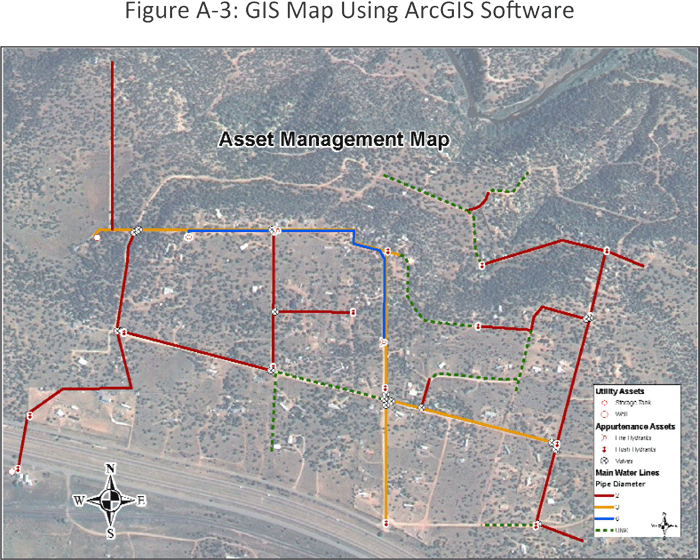
GIS maps using software packages, such as ArcGIS, require base data. This data can be generated internally, gathered through a GPS program, or it may be possible to download data from the internet. Some online resources for data downloads are shown below. An example GIS map is shown in Figure A-3.
- http://www.webgis.com/
- http://www.esri.com/
One caution regarding downloading digital maps from the Internet is the file size. Most high quality digital maps available online have a very large file size and require a high speed Internet connection and a large hard drive to download and store successfully.